Happy New Year!

Mostly about Utah
Yesterday Susan, Shauna, Jill and I hiked Shepard Creek Trail. Shepard Creek Trail winds out of several residential areas in Somerset and Shepard Heights and up a canyon. To get to the trail, from Main Street go east toward the mountains on 1400 North one block. Look for a dirt road to the north and park along 1400 North. Step over the pedestrian gate.
Walk north up the dirt road. This is part of the old Bamberger Railroad right of way. As you come to a large open area, cross near a stone culvert, past the weather station, to the far side of Shepard Creek. The trail parallels the creek winding through trees and crossing two bridges. The first bridge is a large log with a rope as a handrail. Turn left and follow the trail beside the stream.
When you come to some wooden steps, go straight across and continue paralleling the stream until you reach another set of wooden steps. Turn left and cross the second bridge. Follow the trail again paralleling the stream. You will pass some houses. If you take a wrong turn you could end up in someone’s kitchen. So watch for the trail markers.
Keep bearing to the right and eventually you will rise up a short hill to an intersection where there is a bench. The Somerset section of the trail continues on from here.
In 10 or 20 minutes, the trail will come out on Bella Vista Drive. Look up the canyon over your right shoulder to see the break in the chain link fence where the trail continues.
Hike up the dirt road about 200 feet and watch for the trail to cut up the slope to the right. Continue up the trail beyond the chain link fence and hike straight up the dirt road until it “T’s”.
Go left at the “T” and follow this dirt road. After 75 to 100 feet, keep an eye to the right of the road for a faint footpath. Follow the footpath up a ways where it turns to the south. Notice that there is a footpath that travels east up and over a rock outcropping. Another trail goes south from here to Farmington Canyon.
It was a hot day but most of the first part of the trail was shaded. Once out in the open one could feel the sun. Occasionally there was a gentle breeze which felt really good.
We didn’t get to the end of the trail. A hiker on his return trip said it was very steep further up the trail. We weren’t equipped with hiking boots so we eventually turned back after admiring the view.

Today we hiked The Mueller Park Trail in Bountiful. It is a great walk that is mostly shaded all the way up. Much of the trail is gently sloped. From various locations there are good views of the Great Salt Lake and the valley far below.
The Mueller Park Trail is 13 miles round trip. The route begins at the Mueller Park Picnic Grounds in the east Bountiful foothills and ends at a small grassy clearing called Rudy’s Flat. We chose to turn around at Big Rock, called “Elephant Rock” by the locals, to make it a 7 mile round trip.
Mueller Park Trail can be busy on weekends and holidays. Its multi-use designation means it’s open to hikers, mountain bikers, and motorcycles. Today we were passed by numerous bikers.
Click on the images to enlarge. In the video Jill explains what we are doing.

Yesterday found us walking along City Creek Canyon Trail. City Creek was the first water source used by the Mormon Pioneers settling the Salt Lake Valley in 1847. In the early years water flowed through ditches for irrigating gardens. Residents hand dipped water for their culinary and domestic needs. In 1866, City Creek was first diverted into a municipally-owned, piped water distribution system to provide fire protection and culinary water supply to city residents.
The maximum recorded flow in City Creek during the floods of 1983 was 322 cubic feet per second, which resulted in considerable debris flows, flooding and damage through downtown Salt Lake City as State Street was converted into a temporary “river” after debris clogged the city’s storm drain pipes.
We walked up the road 2.5 miles and back again. So not many photographs (click to enlarge). The first two shots about sum it up:
Mike carried on when we turned back. However, we did find a concrete staircase built in the middle of the wilderness by a lost civilization.

It is time for the 4th July parades to begin. Today at 9am found Jill, Sarah, and I at West Bountiful.

Kent and Susan had saved seats for us. From left to right in the photograph below are Rick (me), Kent, Jill, Sarah, Shauna, Mark, Connie, and Susan. Shauna had brought candy just in case we didn’t like the parade offerings. There was also water but it wasn’t needed as I think we had the coolest spot on the parade route.
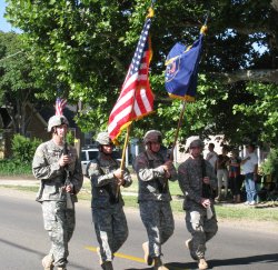
The National Guard carried the flag followed by Mayor James Behunin on a horse. Val Verda Stake, where Jill and I used to live, had a pioneer themed float. There were the usual bands, fire engines, and old cars. There were even Star Wars characters entertaining the crowd. With fifty entries the parade was over in less than an hour which is about the right amount of time for me.